277 Best Sights in Peru

Amantani Island

Fodor's choice

This island has a small set of pre-Inca ruins that are a highlight of a visit here, along with the experience of the traditional life of its mainly agrarian society. Not as pretty as Taquile, Amantani is dusty and brown, though the island is renowned for its homestay programs that bring in boatloads of visitors each day, giving some, albeit touristic, insight into the life of the people here. Facilities and food are basic but cozy. Every tour operator in Puno runs overnight trips here, usually combined with a stop on the Uros Islands and Taquile. Most of the younger generations here speak Spanish and even a smidgen of English, but the older generation speaks only Aymara. Amantani has a population of about 4,500. Sacred fertility rituals are held in its two pre-Inca temples, one of which is dedicated to masculine energy and the other to the feminine. The island is 45 km (28 miles) from Puno and almost three hours away by boat from Taquile.

Casa de Aliaga

El Centro Fodor's choice

From the outside, you'd never guess this was one of Lima's most opulent addresses. Commonly known as Casa de Aliaga, this stunning example of Spanish-colonial architecture a block from the Plaza de Armas was built in 1535 by Jerónimo de Aliaga, one of Pizarro's officers, and has been continuously inhabited by his descendants ever since. Each room boasts a different period décor, from colonial to republican, and Jerónimo's German-made sword is still on display in one of the salons. To visit, you must hire an officially approved guide or go as part of a city tour.

Casa Torre Tagle

El Centro Fodor's choice

This mansion sums up the graceful style of the early 18th century. Flanked by a pair of elegant balconies, the stone entrance is as expertly carved as that of any of the city's churches. The patio is a jewel of the Andalusian baroque, with slender columns supporting delicate Moorish arabesques. The Casa Torre Tagle currently holds offices of the Foreign Ministry and is open to the public only on weekends, when you can check out the tiled ceilings of the ground floor and see the house's 18th-century carriage. Across the street is Casa Goyeneche, which was built some 40 years later in 1771, and was clearly influenced by the rococo movement.

Recommended Fodor's Video

Catedral

Fodor's choice

You can't miss the imposing twin bell towers of this 1612 cathedral, with a facade guarding the entire eastern flank of the Plaza de Armas. As the sun sets the imperial reflection gives the cathedral an amber hue. The interior has high-vaulted ceilings above a beautiful Belgian organ. The ornate wooden pulpit, carved by French artist Buisine-Rigot in 1879, was transported here in the early 1900s. In the back, look for the Virgin of the Sighs statue in her white wedding dress, and the figure of Beata Sor Ana de Los Ángeles, a nun from the Santa Catalina Monastery who was beatified by Pope John Paul II when he stayed in Arequipa in 1990. A fire in 1844 destroyed much of the cathedral, as did an 1868 earthquake, so parts have a neoclassical look. In 2001 another earthquake damaged one of the bell towers, which was repaired to match its sister tower.

Cerámica Seminario

Fodor's choice

Husband-and-wife team Pablo Seminario and Marilú Behar spent years developing their art into what is now known as the Seminario Style—taking the valley's distinctive red clay and turning it into ceramic works using modern adaptations of ancient indigenous techniques and designs. Their works are world-famous, with pieces seen as far off as the Chicago Field Museum. More than a shop or art gallery, here you have the ability to view the workshop where the magic happens and even speak with the artist directly. The store features decorative and utilitarian pieces, as well as others that are pure art, all of which make fabulous Peruvian gifts for yourself or others. Purchases can be shipped to any location.

Chan Chan

Fodor's choice

With its strange, honeycomb-like walls and labyrinth of wavelike parapets, this sprawling ancient capital is the largest adobe city in the world. Its surreal geometry once held boulevards, aqueducts, gardens, palaces, and some 10,000 dwellings. Within its precincts were nine royal compounds, one of which, the royal palace of Tschudi, has been partially restored and opened to the public. Although the city began with the Moche civilization, the Chimú people took control of the region 300 years later and expanded the city to its current size. Although less known than the Incas, who conquered them in 1470, the Chimú were the second-largest empire in South America. Their territory stretched along 1,000 km (620 miles) of the Pacific, from Lima to Tumbes.

Before entering this UNESCO World Heritage site, check out the extensive photographic display of the ruins at the time of discovery and postrestoration. Then, begin at the Tschudi complex, the Plaza Principal, a monstrous square where ceremonies and festivals were held. The throne of the king is thought to have been in front where the ramp is found. The reconstructed walls have depictions of sea otters at their base. From here, head deep into the ruins toward the royal palace and tomb of Señor Chimú. The main corridor is marked by fishnet representations, marking the importance of the sea to these ancient people. You will also find renderings of pelicans, which served as ancient road signs, their beaks pointing to important sections of the city. Just before you arrive at the Recinto Funerario, the funeral chamber of Señor Chimú, you pass a small natural reservoir called a huachaque. Forty-four secondary chambers surround the funeral chamber where the king, Señor Chimú, was buried. In his day it was understood that when you pass to the netherworld you can bring all your worldly necessities with you, and the king was buried with several live concubines and officials and a slew of personal effects, most of which have been looted. Although wind and rain have damaged the city, its size—20 square km (8 square miles)—still impresses.

Ctra. Huanchaco, 5 km (3 miles) northwest of Trujillo, Trujillo, La Libertad, Peru
044-206–304
Sights Details
Rate Includes: S/20, includes admission to Huaca Arco Iris, Huaca Esmeralda, and Museo del Sitio; ticket valid for 48 hours, S/20, includes admission to Huaca Arco Iris, Huaca Esmeralda, and Museo del Sitio; ticket valid for 48 hrs

Chavín de Huántar

Fodor's choice

Indiana Jones would feel right at home in these fascinating ruins, which feature an underground labyrinth of stone corridors and a terrifying idol at their center. The idol, known as the Lanzón, is a 4-meter (13-foot) daggerlike slab with a jaguar's face and serpentine hair, and it was the Holy of Holies for the Chavín people, who were the mother civilization for the Andes. Pilgrims from all over South America would come here to worship, eventually spreading the cult of the so-called Fanged Deity throughout the continent. To make things even crazier, during ceremonies here, Chavín priests and their acolytes would ingest the psychedelic San Pedro cactus, thus facilitating their transformation into the smiling, ferocious god.

Visiting the Chavín archaeological complex, which dates from 1500 BC, is a favorite day trip from Huaraz. The UNESCO World Heritage site sits on the southern edge of the tiny village of the same name, and comprises two separate wings of the main temple, a large U-shaped main plaza, a second plaza surrounded with mysterious carvings, and an on-site museum that houses the grinning stone heads that once looked out from the temple's outer wall. On the drive southeast from the city, you get good views of two Andean peaks, Pucaraju (5,322 meters/17,460 feet) and Yanamarey (5,237 meters/17,180 feet), as well as of the alpine Laguna de Querococha. The eight-hour tour costs about S/50 per person, not including the entrance fee to the ruins. If you'd prefer to get here on your own, regular buses run between Huaraz and Chavín, and you can hire a guide at the entrance to the ruins.

Colca Canyon

Fodor's choice

Flying overhead, you can't miss the green, fertile trough as it cuts through the barren terrain, but it's all an illusion; only scrub brush and cactus cling to the canyon's sheer basalt sides and miles of ancient terraces. The canyon is named for the stone warehouses (colcas) used to store grain by an ancient culture that lived along the walls of the gorge.

Carved into the foothills of the snow-covered Andes and sliced by the silvery Río Colca, Colca Canyon is 3,182 meters (10,440 feet) deep. The more adventurous can embark on a hike into the canyon—typically a two-, three-, or five-day excursion. Bird lovers (and anyone with a penchant for amazement) can visit the Cruz del Condor, currently home to 38-odd animals. Culture seekers can spend a night with a native family. Light hikers and archaeology aficionados can observe points along the rim, and those seeking pure relaxation can hit one of the all-inclusive lodges that offer horseback riding and thermal baths.

Buy Tickets Now

Convento de San Francisco

El Centro Fodor's choice
Convento de San Francisco
Christian Vinces / Shutterstock

With its ornate facade and bell towers, ancient library, and catacombs full of human skulls, the Convento de San Francisco is one of Lima's most impressive sites. The catacombs hold the remains of some 75,000 people, some of whose bones have been arranged in eerie geometric patterns (warning: the narrow, dusty tunnels aren't for the claustrophobic). Meanwhile, the convent's massive church, the Iglesia de San Francisco, is the quintessential example of Lima baroque. Its handsome, carved portal is like an oversized retablo, projecting the church's sacred space out onto the busy street, while the central nave is known for its beautiful ceilings carved in a style called Mudejar (a blend of Moorish and Spanish designs). The 50-minute tour includes the church, the library, ample colonial art, and the catacombs.

Convento de Santo Domingo

El Centro Fodor's choice

If the Iglesia de San Francisco is Lima Gothic—all skulls and penitential gloom—Santo Domingo represents the city's sunny side. From pink facade to rococo tower, every detail here glows with charm. The main cloister is especially enticing: long arcades with Sevillian tiles, gardens redolent of jasmine, coffered ceilings carved from Panamanian oak. But don't overlook the chapter room, which housed Peru's University of San Marcos when it was founded in 1551, or the tombs of Santa Rosa de Lima and San Martín Porres, the first two saints in the New World. In a city given over to the here and now, this temple offers a glimpse into another world.

Cotahuasi Canyon

Fodor's choice

Colca Canyon may be the region's most famous natural attraction, but at 3,354 meters (11,001 feet), Cotahuasi is the world's deepest gorge, beating Colca Canyon by 163 meters (534 feet). It's nearly twice as deep as the Grand Canyon. The canyon has been carved by the Río Cotahuasi, which becomes the Río Ocuña before connecting to the Pacific. Its deepest point is at Ninochaco, below the quaint administrative capital of Quechualla and accessible only by kayak. Kayak explorations first documented the area in the mid-1990s and measured its depth. Since then, paddling the Cotahuasi River's Class V rapids is to kayakers what scaling Mount Everest is to mountaineers.

The ride from Arequipa to the Cotahuasi Canyon ranks with the great scenic roads of the world. As you pass Corire and Toro Muerto, the road rides the western side of snowcapped Nevado Coropuno (6,424 meters, 21,076 feet), Peru's third-highest mountain, for spectacular views as you descend into the valley of Cotahuasi. Logistically speaking, it's a bumpy 11- to 13-hour bus ride or 10 hours by four-wheel drive from Arequipa. The pavement ends in Chuquibamba after about five hours of driving, and then resumes for the last hour of the drive, between the Mirador of Cotahuasi as you descend down to the canyon. There is no fee to enter.

Cruz del Condor

Fodor's choice

Cruz del Condor is a haunt for the giant birds, particularly at dawn, when they soar on the thermal currents rising from the deep valley. At 1,200 meters (3,937 feet), the "condor cross" precipice, between the villages of Pinchollo and Cabanaconde, is the best place to spot them.

From June to August, you're likely to see close to 20 or more condors during a morning visit.

By October and November, many of the female birds are nesting, so your chances of eyeing flocks are slim, though you'll likely spot a few birds. It is possible to take a taxi or bus to the Cruz del Condor from Chivay, but if you take a tour from there, your guide will likely only speak Spanish. If you want a guided tour in English, you will need to set this up with a tour operator ahead of time in Arequipa or Cusco. If you overnight in Cabanaconde or Chivay, you can also visit the Mirador before the sun sets. It's when the condors return to their nests, and you'll have the place all to yourself.

El Brujo

Fodor's choice

This intriguing complex is currently one of the hot properties on the Peruvian archaeological circuit. Plopped down in a barren dune about 6 km (4 miles) from Magdalena, it consists of three distinct huacas, or holy sites: Huaca Cao, Huaca Prieta, and Huaca Cortada. Huaca Cao is the star: in 2006, it was the site of the electrifying discovery of the Lady of Cao, a 1,600-year-old mummy whose tattoos marked her as a Moche priestess or ruler. The finding was immediately compared with that of King Tut's tomb in Egypt, as it completely turned notions of power in pre-Columbian Peru upside down. Equally impressive is the huaca's pyramid itself, where the multicolored friezes of warriors and human sacrifices give a powerful idea of the Moches' artistic skill. The excellent on-site museum is among the most informative of its kind. The other two huacas are still undergoing excavation, but the entrance fee covers all three. The site is well worth the trip from Trujillo.

El Cuarto del Rescate

Fodor's choice

This ransom chamber is the only Inca building still standing in Cajamarca. After Pizarro and his men captured Atahualpa, the Inca king offered to fill the chamber once with gold and twice with silver. The ransom was met, up to a marking on the stone wall, but the war-hardened Spaniards killed Atahualpa anyway. Today, visitors aren't allowed in the room itself, but if you look closely, you can still make out the marks the Inca left in an attempt to buy off his captors.

Ferrocarril Central Andino

Fodor's choice

The Central Highlands' Ferrocarril Central Andino once laid claim to being the world's highest rail route. With the 2006 opening of China's Qinghai–Tibet Railway, the Peru route was knocked down to second place. No matter, though: this is one of the country's most scenic areas, and tracks cut through the mountains and plains all the way from Lima to Huancayo. The line these days is a shadow of what it once was, and trains ply the route only a few times a year. Tickets are easy to come by, but you will have to plan around the infrequent departures if you want the journey to be a centerpiece of your visit to Peru. The railway's website lists departure dates, with Lima–Huancayo service operating just a handful of days between April and November. Trains depart the capital's Desamparados train station for the 12-hour journey to Huancayo, twisting along the 335-km (207-mile) route through the Andes at an average elevation of 4,782 meters (15,685 feet). The engine chugs its way up a slim thread of rails that hugs the slopes, traveling over 59 bridges, around endless hairpin curves, and through 66 tunnels—including the 1,175-meter-long (3,854-foot-long) Galera Tunnel, which, at an altitude of 4,758 meters (15,606 feet), is the climax of the journey. Snacks, lunch, and soft drinks are included in the price. You can request oxygen if you get short of breath over the high passes, and mate de coca flows freely at all hours. The decades-old clásico cars are okay in a pinch, but the newer turístico cars are much more comfortable, with reclining seats and access to the observation and bar car.

Fortress of Ollantaytambo

Fodor's choice

Walk above town to a formidable stone structure, where massive terraces climb to a temple area honoring the sun god. Although the elaborate, walled complex was the valley's main defense against the Antis (jungle people) from the neighboring rain forests, with the sun temple, used for astronomical observation, as well as the Baños de la Ñusta (ceremonial princess baths), archaeologists believe that Ollantaytambo existed for more than defensive purposes, as was typical with Inca constructions. Construction, which began during the reign of Pachacutec but was never completed, incorporates rose-colored granite that was not mined in this part of the valley. The structure was the site of the greatest Inca victory over the Spanish during the wars of conquest. Manco Inca fled here in 1537 with a contingent of troops after the disastrous loss at Sacsayhuamán and routed Spanish forces under Hernando Pizarro. The victory was short-lived: Pizarro regrouped and took the fortress. If you come on your own, take the time to walk up above and through a wooden door at the back to see an Intihuatana ("hitching post of the Sun").

Gocta Waterfall

Fodor's choice

Surprisingly, Gocta, a 771-meter (2,529-foot) waterfall, believed to be the fourth tallest in South America, wasn't brought to the attention of the Peruvian government until 2006. The falls, about 50 km (31 miles) outside town, are strongest during the rainy season, from November to April, though during the dry season, the sun will likely be out, and you will be able to swim at their base. Occasionally, on the 2½-hour hike from Cocachimba (you can hire guides there if you are not coming on a tour from Chachapoyas), you may be able to spot toucans or the endemic yellow-tailed woolly monkey. The best way to appreciate the falls is by staying at the charming, 16-room Gocta Lodge, especially if you prefer the light of the morning or afternoon.

Huaca de la Luna and Huaca del Sol

Fodor's choice

Stark and strange beneath the ash-gray hill that towers over them, these astonishing Moche pyramids were the scenes of bloody human sacrifices. Their exteriors may have eroded, but inside archaeologists have uncovered sinister octopus-shaped reliefs of the great Moche god Ai-Apaec, as well as evidence of a cataclysmic El Niño sequence that effectively destroyed Moche civilization.

The Huacas of the Sun and Moon are located some 10 km (6 miles) outside Trujillo, near the Río Moche. The former is the bigger of the two, but it's not open to the public due to its decayed state. (Built up of 130 million adobe bricks in eight continually expanding stages, its treasures were literally cleaned out of it in 1610, when the Spanish diverted the Río Moche to wash the imperial gold and silver from its innards.) The Huaca of the Moon is awesome in its own right, with numerous exterior and interior walls blazoned with bizarre mythological reliefs. These include spider-like creatures, warriors, and the scowling face of Ai-Apaec, the ferocious god to whom captives were sacrificed at the pyramid's base. These sacrifices probably occurred to propitiate the gods of the weather, but alas, it didn't work. A series of violent El Niño events around the year 600 brought drought and sandstorms, eventually ending the Moche civilization.

When you visit the Huaca de la Luna, you'll start from the top, near the sacrificial altars, and work your way down through the inner galleries to the murals at the base. This was where archaeologists discovered bones of the Moches' victims in recent decades. Be sure to allot time for the excellent museum, which includes exhibits of Moche artwork and informative discussions of the culture's history and religion.

Huaca Pucllana

Miraflores Fodor's choice
Huaca Pucllana
e2dan / Shutterstock

Rising out of a nondescript residential neighborhood is Lima's most-visited huaca, or pre-Columbian temple—a huge, mud-brick platform pyramid that covers several city blocks. The site, which dates from at least the 5th century, has ongoing excavations, and new discoveries are announced every so often. A tiny museum highlights a few of those finds. Knowledgeable, English-speaking guides will lead you through reconstructed sections to the pyramid's top platform and, from there, to an area that is being excavated. This site is most beautiful at night, when parts of it are illuminated. Thirty-minute partial tours are available during this time.

Islas Ballestas

Fodor's choice

Spectacular rocks pummeled by waves and wind into ballestas (arched bows) along the cliffs are what characterize this haven of jagged outcrops and rugged beaches, which serve as home to thousands of marine birds and sea lions. You're not allowed to walk onshore, but you wouldn't want to—the land is calf-deep in guano. Bring a hat, as tourists are moving targets for multitudes of guano-dropping seabirds. Also, be prepared for the smell—between the sea lions and the birds, the odor can be overpowering. A boat provides the best views of the abundant wildlife: sea lions laze on the rocks, surrounded by Humboldt penguins, pelicans, seals, boobies, cormorants, and even condors, which make celebrity appearances for the appreciative crowds in February and March. On route to the islands is Punta Pejerrey, the northernmost point of the isthmus and the best spot for viewing the enormous, cactus-shape Candelabra carved in the cliffs. It's variously said to be a religious symbol from the Chavín culture, a Masonic emblem left by the liberator José de San Martín, or a staff of the Inca creator-god Viracocha.

Buy Tickets Now

Islas Los Uros

Fodor's choice

Known as the floating islands, Islas los Uros are man-made islands woven together with totora reeds that grow in the lake shallows. Replenished often with layers because the underbelly reeds rot, these tiny islands resemble floating bails of hay and average 3 meters (10 feet) thick. They were originally created so communities could escape from attacks from stronger, more aggressive neighbors. Today they stay in one place. While some travelers marvel at these 40-plus islands, some call them floating souvenir stands. Yes, locals sell trinkets, but visiting the floating islands is a glimpse into one of the region's oldest cultures, the Uros. Now mixed with Aymara culture, it's a form of human habitation that evolved over centuries. The closest group of "floating museums" is 7 km (4.35 miles) from Puno.

The islanders make their living by fishing, hunting, cutting reeds, collecting eggs, trapping birds, and selling visitors well-made miniature reed boats and other handicrafts. Virtually every operator offers a stop to the more touristed of these islands as part of their standard lake tour but you can also find trips (or ask your tour operator specifically) to islands less visited where you can get a more intimate look at the culture.

Karajía

Fodor's choice
Discovered in 1985, the six coffins that make up this uncanny funeral site 48 km (30 miles) northwest of Chachapoyas overlook a ruined village and are thought to contain the mummies of shamans and great warriors. The Chachapoyas people built the tombs into a sheer cliffside sometime around the year 1460, and today the eerie funeral masks—together with the bones scattered around the site—provide a haunting reminder of the great chieftains that once held sway over the surrounding country. The Karajía sarcophagi, or "ancient wise men" as the locals call them, originally included eight coffins, but two have collapsed due to earthquakes. This has allowed archaeologists to study the contents of the wood-and-clay structures, which were found to house a single individual in the fetal position, along with all the ceramics and other belongings the deceased carried with him into the afterlife. Visitors today can't get close to the sarcophagi due to their remote location, but the view of them watching over the ravine below is awe-inspiring.

Kuélap

Fodor's choice

Consistently compared to Machu Picchu by visitors, this extraordinary site high in the cloud forests of Chachapoyas was a walled city sufficient unto itself, housing farmers, shamans, and administrators, as well as the "warriors of the cloud" that made up the Chachapoyans' military class. Wandering the circular ruins, with their 12-meter-high (39-foot-high) stone walls and enigmatic carvings of faces and snakes, you catch a haunting glimpse of a fierce people that resisted the Inca Empire to the bitter end.

Kuélap sits at a dizzying 3,100 meters (10,170 feet), high above the Río Utcubamba. Consisting of more than 400 small, rounded buildings, it contains lookout towers, huts with grass roofs (now reconstructed), turrets, and rhomboid friezes typical of the region. The most interesting of the rounded buildings has been dubbed El Tintero (The Inkpot), and features a large underground chamber with a huge pit. Archaeologists hypothesize that the Chachapoyans kept pumas in this pit, dropping human sacrifices into its depths during religious rituals. The ruins are in surprisingly good condition considering the antiquity (1,000 or so years) of the site: the Incas appear to have left it alone when they overran the Chachapoyas people in 1472.

La Catedral

Plaza de Armas Fodor's choice

Dominating the Plaza de Armas, the monumental Cathedral Basilica of the Assumption of the Virgin (or Cusco Cathedral) is one of Cusco's grandest buildings. Built in 1550 on the site of the palace of the Inca Wiracocha and using stones looted from the nearby Inca fortress of Sacsayhuamán, the cathedral is a perfect example of the imposition of the Catholic faith on the indigenous population. The grander the building, went the theory, the more impressive (and seductive) the faith. With soaring ceilings, baroque carvings, enormous oil paintings, and glittering gold-and-silver altars, the cathedral certainly seemed to achieve its aim.

Today, Cusco's Catedral is one of the town's star attractions, noted mainly for its amazing collection of colonial art that mixes Christian and non-Christian imagery. Entering the Catedral from the Sagrada Familia chapel, head to your right to the first nave, where you'll find the famous oil painting (reputed to be the oldest in Cusco) depicting the earthquake that rocked the town in 1650. Among the depictions of burning houses and people fleeing, you'll see a procession in the plaza. Legend has it that during the earthquake, the citizens removed a statue of Jesus on the cross from the Catedral and paraded it around the plaza—halting the quake in its tracks. This statue, now known as the Señor de los Temblores, or Lord of the Earthquakes, is Cusco's patron, and you'll find him depicted in many Cusqueñan paintings.

To see the famous statue, head across the Catedral to the other side, where in the nave and to the right of the passage connecting the Catedral to the adjoining Iglesia del Triumfo, you'll find El Señor himself. The dark color of his skin is often claimed to be a representation of the indigenous people of Cusco; actually, it's the effect of years of candle smoke on the native materials used in its fabrication.

Those interested in the crossover between indigenous and Catholic iconography will find lots to look at. Figures of pumas, the Inca representation of the Earth, are carved on the enormous main doors, and in the adjoining Iglesia del Triumfo you'll see an Andean Christ in one of the altars flanking the exit. No one should miss the spectacular painting of the Last Supper, by the indigenous artist Marcos Zapata, where you'll see the diners tucking into a delicious feast of viscacha (wild chinchilla) and chicha (a corn beverage)!

The cathedral's centerpieces are its massive, solid-silver altar, and the enormous 1659 María Angola bell, the largest in South America, which hangs in one of the towers and can be heard from miles away. Behind the main altar is the original wooden altar primitivo dedicated to St. Paul. The 64-seat cedar choir has rows of carved saints, popes, and bishops, all in stunning detail down to their delicately articulated hands. If you're interested in a more in-depth look, enlist the services of a guide—you'll find them right outside the Catedral. Agree on a price before you start; it will cost a minimum of S/30 per group. Alternatively, there is a free audio guide.

Lago Sandoval

Fodor's choice

Changes in the course of Amazon tributaries have created countless oxbow lakes, which are formed when the riverbed shifts and the abandoned bend fills with water. Lago Sandoval, created by the Madre de Dios River, lies just inside the Tambopata National Reserve, a short trip form Puerto Maldonado. It is a lovely sight, hemmed with lush jungle and a wall of aguaje palms on one end. It is also an ideal spot for wildlife-watching. Herons, egrets, kingfishers, and other waterfowl hunt along its edges; several species of monkeys forage in the lakeside foliage; and chestnut-fronted macaws fly squawking overhead. A family of elusive giant otters lives in Lake Sandoval, making it one of the few places you can hope to see that endangered species. The lake is a 30-minute boat ride east from Puerto Maldonado. Once you disembark, there's a flat-but-muddy 3-km (1.8-mi) hike to a dock in the aguaje palm swamp from where you'll be rowed to the actual lake. Unfortunately, Sandoval is very popular, so you'll see plenty of tourists on the trail and lake. Fewer people visit the lake in the afternoon, but it is best experienced by spending a night or two at the Sandoval Lake Lodge.

Laguna 69

Fodor's choice
Regularly featured on "most beautiful lakes in the world" lists and Instagram bucket lists, this small but stunning turquoise glacial lake near the city of Huaraz and within Parque Nacional Huascarán merits all the hype for its natural beauty and for the spectacular and scenic hike leading to the lake. Treat your visit to Laguna 69 like a high-altitude hike, not a photo op, and be prepared. The trek to Laguna 69 will take your breath away, figuratively and literally, as the lake sits 4,600 meters (15,092 feet) above sea level. Remind yourself that this altitude is just 2,000 feet below base camp at Mount Everest, and then train, pack, and plan time to acclimatize accordingly. It’s possible to get to Laguna 69 and do the hike solo, but it is cheaper (and safer) to take a tour. If you are an experienced high-altitude hiker, you can beat the crowds by staying at a campsite by Llanganuco lake near the hike's trailhead to start your morning hike as early as you wish.

Lagunas de Llanganuco

Fodor's choice

Make sure your camera memory card is empty when you go to see these spectacular glaciers, gorges, lakes, and mountains. Driving through a giant gorge formed millions of years ago by a retreating glacier, you arrive at Lagunas de Llanganuco. The crystalline waters shine a luminescent turquoise in the sunlight; in the shade they're a forbidding inky black. Waterfalls of glacial melt snake their way down the gorge's flanks, falling lightly into the lake. There are many quenual trees (also known as the paper-bark tree) surrounding the lakes. Up above, you'll see treeless alpine meadows and the hanging glaciers of the surrounding mountains. At the lower lake, called Lago Chinancocha, you can hire a rowboat (S/5 per person) to take you to the center. A few trailside signs teach you about local flora and fauna. The easiest way to get here is with an arranged tour from Huaraz (about S/40 plus entrance fee), though if you are going on the Santa Cruz trek you will probably start here. The tours stop here and at many other spots on the Callejón de Huaylas, finishing in Caraz.

Machu Picchu

Fodor's choice

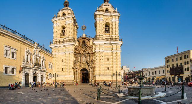
The exquisite architecture of the massive Inca stone structures, the formidable backdrop of steep sugarloaf hills, and the Urubamba River winding far below have made Machu Picchu the iconic symbol of Peru. It's a mystical city, the most famous archaeological site in South America, and one of the world's must-see destinations.

You'll be acutely aware that the world has discovered Machu Picchu since Hiram Bingham's first visit in 1911 if you visit during the June–mid-September high season. Machu Picchu absorbs the huge numbers of visitors, though, and even in the highest of the high season its beauty is so spectacular that it rarely disappoints.

All visitors must go through the main entrance to have their ticket stamped.

You have to show your passport to enter Machu Picchu—if you want it stamped, be sure to stop by the table on the left as you exit the site.

From there, you work your way up through the agricultural areas and to the urban sectors. There are almost no signs inside to explain what you're seeing; booklets and maps are for sale at the entrance. You must purchase your ticket for the hour of entrance. The first slot begins at 6 am, and continues hourly through to 3 pm, which is the final slot. According to regulations, you must be accompanied by a licensed guide, although this is not necessarily enforced. You will have just four hours in the site from entrance to exit. If you purchase an entry to hike Huayna Picchu or Machu Picchu Mountain, you may stay in the site for six hours.

The English-language names of the structures within the city were assigned by Bingham. Call it inertia, but those labels have stuck, even though the late Yale historian's nomenclature was mostly off base.

The Storage Houses are the first structures you encounter after coming through the main entrance. The Inca carved terraces into the hillsides to grow produce and minimize erosion. Corn was the likely crop cultivated.

The Guardhouse and Funeral Rock are a 20-minute walk up to the left of the entrance, and they provide the quintessential Machu Picchu vista. Nothing beats the view in person, especially with a misty sunrise. Bodies of nobles likely lay in state here, where they would have been eviscerated, dried, and prepared for mummification.

The Temple of the Sun is a marvel of perfect Inca stone assembly. On June 21 (winter solstice in the Southern Hemisphere; sometimes June 20 or June 22), sunlight shines through a small, trapezoid-shaped window and onto the middle of a large, flat granite stone presumed to be an Inca calendar. Looking out the window, astronomers saw the constellation Pleiades, revered as a symbol of crop fertility. Bingham dubbed the small cave below "the royal tomb," though no human remains were found at the time of his discovery.

Fountains. A series of 16 small fountains are linked to the Inca worship of water.

The Palace of the Princess, a likely misnomer, is a two-story building that adjoins the temple.

The Principal Temple is so dubbed because its masonry is among Machu Picchu's best. The three-walled structure is a masterpiece of mortarless stone construction. A rock in front of the temple acts as a compass—test it out by placing your smartphone with compass app showing on top of it.

Three Windows. A stone staircase leads to the three-walled structure. The entire east wall is hewn from a single rock with trapezoidal windows cut into it.

Intihuatana. A hillock leads to the "hitching post of the Sun." Every important Inca center had one of these vertical stone columns (called gnomons). Their function likely had to do with astronomical observation and agricultural planning. The Spanish destroyed most of them, seeing the posts as objects of pagan worship. Machu Picchu's is one of the few to survive—partially at least. Its top was accidentally knocked off in 2001 during the filming of a Cusqueña beer commercial.

The Sacred Rock takes the shape, in miniature, of the mountain range visible behind it.

The Temple of the Condor is so named because the positioning of the stones resembles a giant condor, the symbol of heaven in the Inca cosmos. In this temple, priests likely sacrificed llamas, pouring their blood onto the "condor's" head. The structure's many small chambers led Bingham to dub it a "prison," a concept that did not likely exist in Inca society.

Day-Tripping vs. Overnight: If you are just doing a regular tour of Machu Picchu, you're probably best off arriving at Aguas Calientes midmorning and getting a ticket for the hour 30 minutes after your arrival. You still may want to stay the night in Aguas Calientes so that you don't have such a long day of travel. If you're going to hike one of the mountains, then you will need to spend the night before in town in order to arrive in time for your hike. In that case, you may also want to spend a second night, after your visit, to allow you time to recuperate and to take a nice, hot, post-hike shower.

Buying a Ticket: Machu Picchu tickets can be purchased online with a Visa card on www.machupicchu.gob.pe, and it’s advisable to purchase your tickets at least a month in advance. If you have your heart set on hiking Huayna Picchu, you need to purchase the ticket at least two to three months in advance, more during high tourist season. If you arrive in Peru without an admission ticket, you must purchase one in Cusco or in Aguas Calientes at the Centro Cultural Machu Picchu (Av. Pachacutec 103, 084/211–196S/152Daily 5:45 am–8:30 pm. No credit cards. Purchase is in person only and with passport). There is no ticket booth at the site's entrance. If you are with a tour, the tickets are most likely taken care of for you. If you wait until you arrive in Aguas Calientes, however, you may not have much choice in entrance times. Bus service begins at 5:30 am, and with the new timed entries, you can wait to line up 30 minutes before your hour. The ticket is valid only for the date it is purchased. So if you visit the ruins in the afternoon, and plan to stay the night and return the next morning, you’ll have to buy two tickets. The park is open from 6 am to 5:30 pm.

Hiring a Guide: There are always guides for hire waiting outside Machu Picchu. With the new rules, the numbers are likely to increase; however, you are best off booking your Machu Picchu trip with an agency, not only because you may not be able to enter without a guide, but also because the best ones tend to work with agencies and get booked up ahead of time. People with guides are given preference in the line to enter.

Catching the Bus: If you’re a day-tripper, follow the crowd out of the rail station about two blocks to the Consettur Machupicchu shuttle buses, which ferry you up a series of switchbacks to the ruins, a journey of 20 minutes. Buy your US$24 round-trip (US$12 one-way) ticket up the street from the line of buses before boarding. Bus tickets can be purchased in U.S. dollars or soles. If you’re staying overnight, check in to your lodging first, and then come back to buy a ticket. Although there is no assigned seating, tickets will have your name and passport number on them. Save time by making a reservation at www.consettur.com, printing out the reservation confirmation, and taking it to the booth. The website also offers the ability to pay with credit card, but this does not always work.

Buses leave Aguas Calientes for the site beginning at 5:30 am and continue more or less every 10 minutes, with a big push in midmorning as the trains arrive, until the historic site closes around 5:30 pm. If you’re heading back to Cusco, take the bus back down at least an hour before your train departs. It’s also possible to walk to and from the ruins to Aguas Calientes, but this hike will take you a good 60 to 90 minutes either way, and it doesn't offer much in the way of interesting views.

Being Prepared: Being high above the valley floor makes you forget that Machu Picchu sits 2,490 meters (8,170 feet) above sea level, a much lower altitude than Cusco. It gets warm, and the ruins have little shade. Sunscreen, a hat, and water are musts. Officially, no food or drinks are permitted, but you can bring in a reusable bottle of water. Large packs must be left at the entrance.

Practicalities: A snack bar is a few feet from where the buses deposit you at the entrance gate, and the Belmond Sanctuary Lodge Machu Picchu has a US$40 lunch buffet open to the public. Bathrooms cost S/1, and toilet paper is provided. There are no bathrooms inside the sanctuary, and you may not exit and reenter to use the ones outside.

The Inca Trail, Abridged: Most Cusco tour operators market a two-day, one-night Inca Trail excursion. An Inca Trail permit is required and you must go with a licensed operator; book well in advance. The excursion begins at Km 104, a stop on the Cusco/Sacred Valley–Machu Picchu train line. All of the hiking happens on the first day, and you get to enter Machu Picchu through the Sun Gate and spend the night at a hotel in Aguas Calientes. The second day is not a trail hike but a guided visit to the site.

Av. Pachacutec 103, Aguas Calientes, Cusco, Peru
084-211–256-Aguas Calientes
Sights Details
Rate Includes: S/152; S/200 with Huayna Picchu or Machu Picchu Mountain, Ticket office: 5:45 am–8:30 pm; Machu Picchu ruins: 6 am–5:30 pm

Manu Biosphere Reserve

Fodor's choice

Scientists consider the Manu Biosphere Reserve to be one of the most biodiverse places on earth, and much of its vast wilderness has barely been studied, since it is still home to uncontacted indigenous groups. Straddling the boundary of the Madre de Dios and Cusco provinces, the reserve is Peru's second-largest protected area, encompassing more than 4½ million acres of pristine tropical forests. Its extraordinary biological diversity is in part due to its precipitous terrain, which ranges in altitude from 3,450 meters (12,000 feet) down to 300 meters (less than 1,000 feet). This geographical diversity results in varied ecosystems—from high-altitude puna grasslands to luxuriant cloud forest and seemingly endless rainforest—which, in turn, shelter a stunning range of flora and fauna. To top it off, a near-total absence of humans means that the animals here are less skittish and more easily observed.

Whereas Manu's highland cloud forest is home to dozens of hummingbird species, the spectacular cock-of-the-rock, and the Andean bear (aka spectacled bear), the reserve's lower parts hold most of its more than 200 mammal species, including 13 species of monkeys, which scrutinize visitors with the same curiosity they elicit. White caimans sun themselves on sandy riverbanks, while the larger black caimans lurk in the oxbow lakes. With luck, you may see a tapir, giant river otter, or one of the region's elusive jaguars. You are bound to see a sampling of the avian life that has made Manu world-famous. The area counts more than 1,000 bird species, one-ninth of those known to science. They include several species of macaws, toucans, jacamars, cocoi herons, harpy eagles, razor-billed currasows, blue-headed parrots, and horned screamers. Manu is also home to hundreds of colorful butterfly species and an array of ants, beetles, and spiders, as well as millions of mosquitoes, so be sure to take an ample supply of insect repellent.

A UNESCO World Heritage Site, the Biosphere Reserve is divided into three distinct zones. The smallest, and most accessible, is what's known as the "cultural zone," home to several indigenous groups and the majority of the jungle lodges. Access is permitted to all—even independent travelers, in theory—though it would be extremely difficult to visit it on your own. About three times the size of the cultural zone, Manu's "reserved zone" contains various nature lodges, which can only be visited on a guided tour with one of a dozen agencies authorized to take people into the area. The western 80% of Manu is designated a national park and is closed to all but authorized researchers and the indigenous peoples who reside there.

Mines of Santa Bárbara

Fodor's choice
This ghostly abandoned mine dates from 1563, when the discovery of mercury in the hills south of Huancavelica turned the region into a key cog in Spain's precious-metals machine. It closed in 1786, after one of the mine shafts collapsed, killing 200 workers. If you make the two-hour trek from town, you can see what remains of the former mining village, complete with church and school. The mine itself, however, is sealed off due to the poisonous gases still present inside. You can also pay a taxi driver S/60 to take you and wait as you explore. The mine is tentatively slated to become a UNESCO World Heritage Site, so to get the jump on the crowds, go now.